


Making Spatial Thinking Visible
Source/Author: Jeanne Simons, First Grade Teacher
January 27, 2023
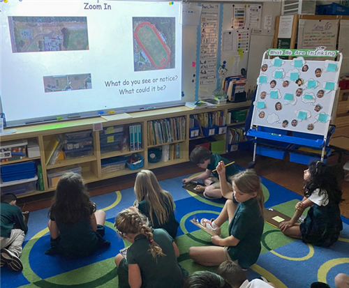
Shorecrest first graders regularly take part in activities that "Make Thinking Visible." Last week Mrs. Silvers’ and Mrs. Simons’ students, who are studying maps, participated in a photo zoom-in. The Chargers saw a small portion of a larger image projected on the board. They made guesses as to what the larger picture might be based on the little visible piece.
The teachers slowly revealed more of the image, and the students made new guesses, adding to the original pool of guesses. Before all the pieces of the photo were visible, the students made one last guess. It was quite incredible that the youngsters were able to figure out that the image - before it was completely revealed - was an aerial view of Shorecrest's campus. Once the full campus birds-eye view was projected, they were able to identify buildings and areas of the campus.
The teachers slowly revealed more of the image, and the students made new guesses, adding to the original pool of guesses. Before all the pieces of the photo were visible, the students made one last guess. It was quite incredible that the youngsters were able to figure out that the image - before it was completely revealed - was an aerial view of Shorecrest's campus. Once the full campus birds-eye view was projected, they were able to identify buildings and areas of the campus.
The first grade mapping inquiry allows students to comprehend and analyze concepts related to the places and spaces around them. Spatial thinking is one of the most important skills that students can develop as they learn geography, environmental sciences, math and art skills, including shapes, scale, and placement among others. They also enhance their language skills as they collaborate and communicate about spatial relationships.
In addition, when teachers can see the process students are using to analyze problems, make predictions, and draw conclusions, it becomes easier to support and guide their thinking in the student-centered classroom.
In addition, when teachers can see the process students are using to analyze problems, make predictions, and draw conclusions, it becomes easier to support and guide their thinking in the student-centered classroom.


